WESTFIELD—For all that’s been said about the Barnes Aquifer, there hasn’t been a lot of explanation about what it really is.
The aquifer has come up in countless conversations as the Westfield water crisis continues. City officials mention it regularly, news stories about the water issues utilize the title when referring to the underground water sources but residents have been heard asking, “What is the Barnes Aquifer, anyway?”
Well, it all started a very long time ago.
About 2.5 million years ago, the globe started to see its last great ice age known as the Pleistocene Epoch. The globe had significant amounts of ice, including up to 30 percent estimated ice coverage at its highest point. These conditions were part of the repeated glaciations that would happen, with several glaciers melting and moving across continents over the next two-plus million years.
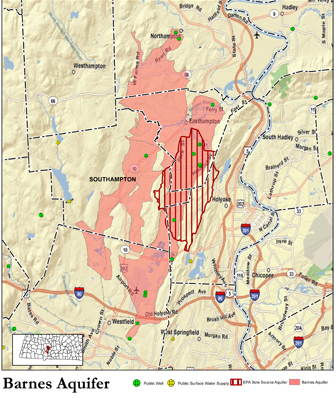
Barns Aquifer map from the BAPAC website.
As these glaciers moved and melted, they would collect and distribute sediment wherever meltwater from them went to. The smaller sediment like silt and clay, according to the Barnes Aquifer Protective Advisory Committee (BAPAC) website, would flow out to lakes or the ocean, while larger sediment like rocks and gravel would settle in the floodplains created by meltwater. It was here were the creation of the aquifer really began.
When the glaciers melted again about 15,000 years ago it left behind a large glacial lake called Lake Hitchcock. This lake, named for famed local geologist and former Amherst College President Edward Hitchcock, stretched across New England, and at one point covered 200 miles worth of land, from modern-day Rocky Hill, Connecticut, to St. Johnsbury, Vermont, which is in the upper-northeast portion of the Green Mountain state.
Lake Hitchcock continued to provide the sediment at the bottom of itself through the constant flowing in of glacial water and freezing. After about 3,000 years of existence, the lake drained following the collapse of a natural dam in the area of modern-day Rocky Hill. This draining process went on for an estimated 200 to 300 years, according to the National Park Service’s Sait-Gauden website.
All this led to large exposed areas well-sorted sand and sediment once the lake drained. This well-sorted sand and sediment also act as incredible filters for water, which is why the aquifer provides potable drinking water for 60,000 people, according to the BAPAC website.
Currently, the aquifer is located under portions of Westfield, Southampton, Northampton and Holyoke, and is under the majority of Easthampton city lines. More specifically, south to north it extends roughly from I-90 in Westfield up through Southampton and Easthampton to Northampton, while west to east it extends roughly route 10 in Southampton to the Holyoke-Easthampton border. However, the aquifer is an irregularly-shaped water source, so exact boundaries vary.
So, to answer the question of “What is the Barnes Aquifer, anyway,” in the end it is really just sand and sediment from a glacier. But what important stuff it is.
NOTE: This story also had information contributed by Charles “Woody” Darling from the Westfield Water Resources Department. For more information visit the BAPAC website at: http://bapac.pvpc.org/
