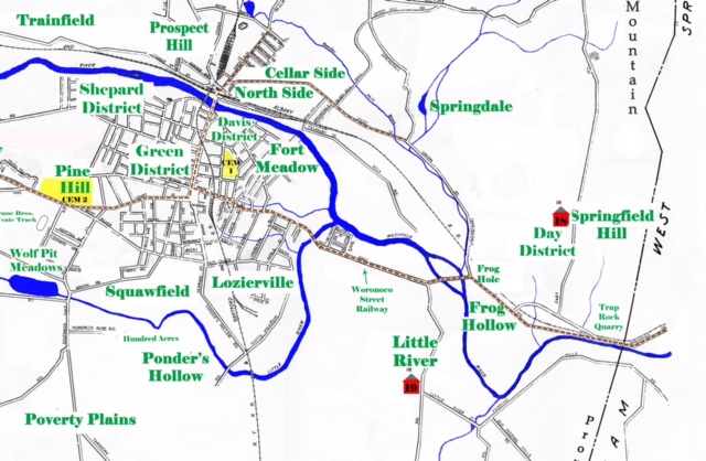
WESTFIELD – For history buffs, a new map, circa 1900, will soon be available for purchase through the Westfield Athenaeum, highlighting places including Hoop Pole and Frog Hollow and much more.
“We undertook this project to answer reference questions about places that have been lost or changed their name over time,” said Kate Deviny, archives and museum coordinator.
Deviny said that in older reference books, newspaper articles and documents, there are references to places including Fox Meadow, Madagascar, Hoop Pole, Frog Hollow, and Trainfield, among many others.
“This map shows those original names and thereby orients the researcher to where the blacks lived, or the training field of World War I,” she said.
Deviny was assisted in this research effort by Bruce Cortis, Bob Brown and Ann Tumavicus.
“Bruce did the physical compilation and coordination of all the information to make sure it was accurate,” said Deviny. “He also spent countless hours creating the map in Photoshop. The rest of us researched, compared old maps and brought information to Bruce.”
The map is formatted as an 18” x 24” sheet with the actual image of 16” x 22” to allow for a mat or border so the text would not be lost, according to Cortis.
Deviny said for a history buff, the map is “very valuable” since it accurately places the older names which have been used in all the books written about historical Westfield.
“The map also shows the extent of growth in 1900,” she said. “Today we have far more roads and not the same access to Holyoke and the Owen District (which is now Barnes Airport).”
Deviny said at times it was “surprising” how hard it was to “nail down” specific places including roads.
“Some roads have been discontinued or rerouted which made them difficult to map,” she said. “Also, school districts have been named over time, but not delineated in boundaries or placed on a map.”
Deviny added that one of the biggest surprises in 1900 was 20 grade schools noted on the map.
Some names have stood the test of time including Wyben, East Farms, Hampden Ponds and Pochassic, according to Deviny.
“While some names remain the same, most have changed over time,” she said. “After all, the Owen family is not the only family living off East Mountain Road, so it is no longer the Owen District.”
The Athenaeum is still researching its printing options, so a firm selling date still has to be determined. The committee expects that the cost of the map could range from $15 to $18, according to Cortis. Any proceeds raised from this project will benefit the library.
For individuals interested in purchasing the map, send an email inquiry to Deviny at [email protected].
1900 city map perfect for history maps
By
Posted on