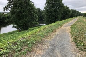
Westfield River Levee Multi-Use Trail going east. (Photo by Amy Porter)
WESTFIELD – Westfield’s Engineering Department has submitted 25% plans to the Massachusetts Department of Transportation for the Westfield River Levee Multi-Use Trail.
The move followed acceptance by the City Council on July 8 of the first installment of a $300,000 grant from the MassDOT for the design work. The city also has $175,000 in local funds for the work from the previous fiscal year budget, which will meet the matching requirement, according to City Engineer Mark Cressotti.
The Westfield River Levee Multi-Use Trail will extend the Westfield River Esplanade, located along the levee between Sackett Street and Elm Street, a mile to the west to Ellsworth Street, and a mile to the east, ending at Riding Williams Way. The esplanade is at the intersection of the future Columbia Greenway Rail Trail central downtown portion and the recently converted Railroad Bridge.
Cressotti said the trail will provide an east-west road connect for neighborhoods along the levee to downtown destinations including the CGRT. In addition, the trail will connect to Franklin Avenue Elementary School, slated for expansion, and Whitney Field playground to the west; and to the Chapman playground and Senior Center, many of whose members use the trail, to the east. The eastern portion runs parallel with Meadow Street, passing a canoe launch and other access points to the Westfield River, and ends at the Riding Williams Way Flood Control Pump Station, where a parking lot will probably be added, Cressotti said.
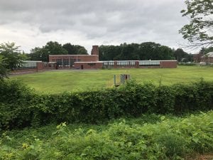
The multi-use trail runs behind Franklin Avenue Elementary School, which is slated for a building project. (Photo by Amy Porter)
There is already a well-worn walking trail on the levee, which Cressotti said is certified, in good shape, and groomed twice a year by the city. He said the work they will be doing will add mass to the levee, widening the crest to 16 feet and the multi-use trail to 10 feet. In order to widen the crest, they will kick out the toe on the protected side away from the river, or put in retaining walls of large concrete blocks, like those next to the CGRT by Stop & Shop.
Some sheds and properties encroaching on city land next to the levee will be disturbed, and property owners are being notified. “We’re going to have some impacts,” Cressotti said.
However, he also said that they have found the presence of a multi-use trail increases property values, which has occurred in the Ridgecrest, Munger Hill and Colony Drive area.
The total project, which has been accepted by the MassDOT, is anticipated to cost $4.5 million, which Cressotti said will ostensibly be paid for with federal and state funds, although he is also pursuing other, quicker, funding.
Now that the 25% design has been submitted; MassDOT will respond to the design, then the city will respond to comments. Following those steps, a public hearing will be scheduled by the end of 2019 to review the project with abutting neighborhoods and the general public.
The 25% design is available on the city website at www.cityofwestfield.org under Active Projects in the Engineering Department.

Westfield City Engineer Mark Cressotti (WNG File Photo)
The central portion of the Columbia Greenway Rail Trail which will connect to the esplanade, a MassDOT project, is out to bid, and the tentative date for opening bids is at the end of August. Cressotti is hopeful that the state will award the contract and start construction this fall, working through the winter. He said the project could then conceivably be completed by the end of 2020.
“I think they have a shot at it. Being optimistic, it’s not a lot of work other than the bridges,” Cressotti said.