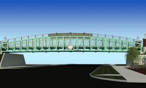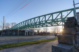
The new Columbia Greenway Rail Trail bridge at Main Street. (THE WESTFIELD NEWS FILE PHOTO)
WESTFIELD – The two riders pulled their bikes to a halt and peered through the chain link fence at the steel and concrete bridge on the other side. They were disappointed that the Columbia Greenway Rail Trail ended at Main Street, but are anxious for the new downtown section to open.
“Westfield does a nice job with their trail – better than some parts of Connecticut,” said Tom Kulig, who along with fellow East Granby resident Jeff Moger rode from Connecticut to Westfield. “This is the end of the trail for us, so it will be nice when this section is finished and we can go further,” added Kulig.
He – along with the many other bicyclists, walkers, and runners who use Westfield’s rail trail – won’t have long to wait. City Engineer Mark Cressotti said he expects the final downtown section – which includes the signature bridge over Main Street – to open in October.
The project, which included 3,500 feet of multiuse recreational trail and the rehabilitation/replacement of five railroad bridges in downtown, begins at the end of the existing trail, near Main Street, and ends at the recently constructed Columbia Greenway North segment at the Westfield River railroad bridge.
In addition to the new Main Street bridge, other improvements included rehabilitation of the bridge over Elm Street, and replacement of bridges over Thomas, Chapel and Orange streets. It will eventually continue north from the park, encompassing neighborhoods and commercial districts, to connect with rail trails in the communities of Southampton, Easthampton (the Manhan Rail Trail), and Northampton (the Norwottuck Rail Trail).
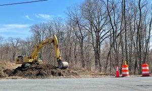
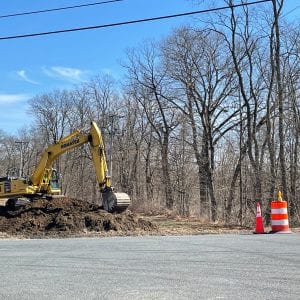
MassDOT is currently designing a section of the trail along the Route 10/Southampton Rd corridor. The Maryland-based firm of Toole Design Group will conduct a feasibility study to analyze various routes to connect the Columbia Greenway with the MassDOT section along Southampton Rd. near Barnes Regional Airport.
Toole Design will document and analyze existing conditions, propose trail alignment alternatives, lead public outreach and engagement, and conduct a detailed feasibility study on the preferred design option.
The intent of the study, he explained, is to select a route for the trail that “optimizes safety and comfort” for users, promotes biking, and walking, and connects to important local destinations such as schools, parks, and commercial districts.
“This section north of the turnpike doesn’t have a 5-foot-wide shoulder for a bike lane. Plus, it’s a busy travel area that’s not conducive to a multiuse trail,” said Cressotti. “We want this to be an attractive piece of a regional trail network. It will serve important functions as both a local and regional active transportation connector.”
Cressotti said it is critical to the success of the project — and the final route selection – for “stakeholder partners” to be involved in the process. Those partners include MassDOT, Pioneer Valley Railroad and other rail companies, Friends of the Columbia Greenway Rail Trail (FOCGRT), business and citizen groups, and city agencies.
He said having partners join early and continue throughout the process will allow for “the flow of ideas and avoid permitting problems or other dead ends” at the final stages of the feasibility study. Cressotti said this will put the city in “an ideal position to pursue design and construction of the multiuse trail” and continue the “great investments in active transportation” that Westfield already has made.
The feasibility study is being paid for by a Mass Trails Grant through the state Department of Conservation in the amount of $61,500, with the city providing $15,500, for a total of $77,000.
The Columbia Greenway Rail Trail began as an initiative stemming from a 2009 downtown visioning and strategic planning effort. That same year, FOCGRT was established to help ensure the entirety of the rail trail was completed and to work toward a more bicycle and pedestrian friendly community. The first section, from Southwick to just south of the “Tin Bridge” area near South Broad Street, was completed in fall 2012.
In 2015, the city and FOCGRT established guidelines “for the acceptance of donations to the City of Westfield, the responsibility for the maintenance of the trails and any structures of appurtenances thereof.”
Carmel Steger, who serves as chair of FOCGRT, said its 15-member board of directors meets monthly with Cressotti to get updates on stages of the trail’s development and other pedestrian and bike paths under consideration and design by the engineering department.
“There’s tremendous growth for these routes in Westfield,” said Steger. She added that various city departments, commissions, and committees have been working on the best ways to use city resources to create safe and accessible walking and bike paths throughout Westfield’s neighborhoods.
She said FOCGRT’s board actively monitors trail use and publishes data so the city knows how much the trails are used, when there are violations of safety or prohibited activity, or vandalism. The advocacy group also plans events that engage the public and explains the proper use of the trail, bike safety, and promotes businesses near the trail that rely on its foot traffic.
On Aug. 28, the FOCGRT will have a table at the Westfield On Weekends concert at the South Middle School to encourage the public to support the group through annual memberships.
Steger said FOCGRT also will hold a fundraiser this fall in partnership with New Horizons Bike with the Great River Ride on Sunday, Oct. 10. “This annual ride is well regarded by avid cyclists,” she added.
For a $50 entry fee, cyclists can choose between five rides; 108 miles, 62 miles, 36 miles, a 36-mile gravel ride, or a 30-mile winery ride. All proceeds go to FOCGRT. Visit www.bikereg.com and search for Great River Ride for additional information and to register. Registration closes Oct. 1.
The Columbia Greenway links many historic, scenic, natural, and cultural sites in Westfield, and has been a key part of promoting biking and walking in the city. It’s part of a multimodal linear “park” that follows a portion of the tracks of the former New Haven Railroad and the old canal that ran from Northampton to New Haven, Connecticut.
The trail traverses downtown Westfield on a mostly elevated line for a total of 3.2 miles, stretching from Southwick in the south to the Great River Bridge in the north. With the exception of a surface street crossing at Shaker Rd., the Columbia trail incorporates bridge crossings of all streets in downtown.